
Many outdoor GPS receivers can make a record of the route while you are walking or bicycling. The route is saved in a Track log file. For Garmin GPS devices you can display the recorded route in the MapSource program. Tracklog files with the file extension gpx can be loaded in most GPS devices and can also be displayed in the Google Earth program.
You can use the Tracklog file to walk the route again, by using the TraceBack function of the GPS. However many GPS receivers, like my Garmin GPSmap 60Cx, can handle only 500 data points with the TraceBack function. If you load a Tracklog file with more data points, the GPS gives a message "Track Truncated" and during the walk you see that the last part of the route can not be used.
Program ConvertTrack can remove Tracklog points which are not significant for the track and limit in that way the number of points to 500 or less. If a next Tracklog point goes in about the same direction of the previous point, it will be removed. The Time information is also removed, resulting in a small Tracklog file. The Height can be copied to the output file or it can be omitted. If the tracklog file contains more then one track, these tracks are automatically linked in the derived file. Routes and waypoints are also automatically removed in the output file.
I am not very satisfied with the Traceback function of my GPSmap 60cX, therefore I have added the possibility to convert a tracklog in a route. With such a file it is easier to navigate with my GPS.
Finally it is possible to convert a tracklog file in a Google Earth kml file, which allows you to show your tracks on the Internet with Google Earth or Google Maps. It is also possible to read a Google Earth kml file and convert it to a gpx file for loading in your GPS.
More information about GPS devices, GPS software and downloadable GPS tracks can be found on the GPS page of my web site.
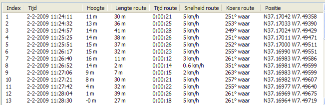
If you display a tracklog file in MapSource, you see that many points are on the same strait line:
You see this too if you display the track properties:
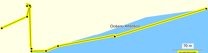
The first and last point of a track is always copied. For this example we defined a minimum direction change of 10 degrees, so points 2-7 will be removed.
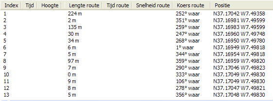
The derived tracklog shows the following map and track properties:
You see the effect of this program in the next tracklog:
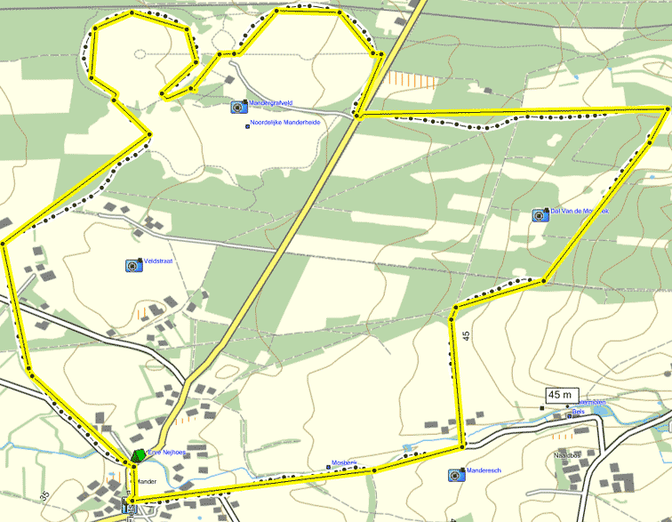
The black track with the most points is the original trackof 510 points. The yellow track is the derived tracklog file where a maximum of 50 points was requested.
If you have no topo GPS map for a region where you like to plan a hike, you can not make a route for your GPS with MapSource. Do it in that case with program Google Earth..
Open Google Earth, click in window Places on 'Temporarily places' and make your route with menu item Add / Placemark. Give the first point the name 00, the 2nd point 01 etc. Save your waypoints as a kml file and open the kml file with program ConvertTrack. Save the waypoints there as a gpx Route file and transfer it to your GPS with the MapSource program.
It is also possible to make a track in Google in Google Earth: Open Google Earth, click in window Places on 'Temporarily places' and make your track with menu item Add / Path. Enter the name of the path in the new window and click with the left mouse button on the starting point of the path. Continue with the next corner point in your path or keep the mouse button down and move over the the planned track. If you are at the endpoint, click on the Ok button of the path window. Save your path as a kml file and open the kml file with program ConvertTrack. Save the path there as a gpx Track or Route file and transfer it to your GPS with the MapSource program.
This is a simple program with one main window without a menu. Help will be displayed in another window.
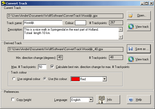
Above you see the contents of the main window after the button ‘Write’ has been clicked.
The first action you have to do after the start of the program, is the selection of the tracklog file to be processed. You do this by clicking on the 'Open' button. After the selection of the Tracklog file, the file is read and the filename is displayed, with the track name, the track description and the number of found tracklog points is. You can edit the Track name and the description, the changes will be copied to the derived Tracklog file.
You can also open a gpx or kml file for this program by browsing with the Explorer to the file. Click with the right mouse button on the file and select in the menu item 'Open with'. Select next in the menu the item ConvertTrack.
If you do this the first time, you should select program ConvertTrack by browsing to the ConvertTrack.exe file.
Before you save the derived track you should select how the points should be eliminated. The easiest way is to define the maximum number of track points in the derived Track file and let the program search for the best minimum direction change so that the number of Track points in the derived file is equal or just below that number. Check therefore the checkbox before the text 'Calculate best minimum change for maximum # Trackpoints'. The program starts the iteration with a minimum direction change of 1 degrees and continues to maximum 60 degrees. If the requested minimum # points could not be reached, the # trackpoints in the derived file is displayed in red. In that case you should rise the maximum # points in the derived track.
If you uncheck the checkbox, you can define the minimum direction change in degrees by entering the required value in the text box. If you enter there the value 0, no points are eliminated and only the time and height information is removed.
Finally you chose the colour for the derived track.
You can also open a kml file in this program. If such a file contains both Waypoints and a Track, the Track is not read. No filtering is applied to such a file if it is saved.
The derived tracklog file will be saved to a disc after you click the 'Save as' button and you entered the name and location of the derived tracklog file. The tracklog file can be saved as a gpx Tracklog file or a gpx Route which can be loaded in a GPS or as a kml file which can be displayed in the Google Earth program. After the file is saved, the name and location is displayed with the applied minimum direction change and the number of written tracklog points.
With the buttons 'View track' you can view the original and converted track with the default program for gpx en kml files. In most cases these file types are assigned to the MapSource and Google Earth program.
If the height of a point should not be copied to the output file, you should uncheck the check-box 'Copy height' .
The combo-box behind 'Language:' allows you to select another language: Nederlands (Dutch) or English.
After clicking the 'Info' button the system will show the about box. It shows the program version number and information about the author of the program.
After clicking the 'Help' button the system will show this help information in a new window. If you have the Shift or Ctrl key pressed while you click the help button, the program shows the Help index of the help file.
On the lower side of the help window, you see three buttons. By clicking the ‘Back’ button, you go back to the main program window. By clicking the ‘Index’ button, the system will show the help index. By clicking the ‘Close’ button, the program will close the help window and go back to the main program window.
Also without the use of the 'Help' button you can get help: If you move the mouse slowly over a control (button, text before edit box, checkbox) the system shows a hint message explaining the function of the control.
The Microsoft .NET application ClickOnce deployment procedure is now used. The program is no longer in directory'C:\Program Files\Wolff Software\ConvertTrack' but somewhere in a subdirectory of %Userprofile%\AppData\Local\Apps\2.0\
Tracks in KML files were not correctly read, this is improved.
It is now possible to make a path in Google Earth and convert it to a gpx file with this program.
In the previous version the coordinates of trackpoints in a kml file were not correctly read. This has been corrected in the current version.
A new check-box 'Copy height' is added, which allows you to copy the height of each trackpoint to the output file if you like.
In the previous version the coordinates of waypoints in a kml file were not correctly read. This has been corrected in the current version.
The filtering of tracklog files is improved: the parameter, for the maximum number of consecutive points which can be deleted, is removed.
It is now also possible to read kml files with this program.
The filtering of tracklog files is improved.
It is now possible to save the derived track also as Route file. Therefore the name of the program has been changed from ReduceTracklogPoints to ConvertTrack.
Two new View buttons allow you to display the original and the converted track with the standard programs assigned to gpx and kml files.
The contents of the description block of the tracklog file is now shown and the contents can be edited for the converted file.
It is now possible to select the colour of the track in the derived file.
A new parameter, the maximum number of consecutive points which can be deleted, is introduced to improve the elimination method if a large circle is followed.
It is now possible to select another language: Dutch or English.
Invalid characters in the track name are removed before the track name is used as default output filename.
Install this program with the installation program by clicking the Windows ‘Start’ button and selecting next item ‘Execute’. Fill the box by browsing to file setup.exe file which was downloaded from the download page of the author of this program. Click OK and follow the instructions of the installation program..
To remove this program from your PC, go to the Windows Configurations menu and select there the function ‘Software’. Next click entry ConvertTrack in the list and click the button ‘Remove’ in that entry. Before you install a new version of this program, you should first remove the old version of the program.
This Microsoft .NET Framework 3.5 Service Pack 1 should be installed on your PC before you install program ConvertTrack. Check as follows whether this Framework is installed on your PC. Start the Windows Configurations menu and select there the function ‘Software'. If the Microsoft .NET Framework 3.5 Service Pack 1 has been installed you see it in the list.
If the .Net Framework is not installed, you can do that from the Microsoft download site.
If the correct .Net Framework is on your PC, install next program ConvertTrack by clicking the Windows 'Start' button. Select 'Execute' and click next on the button 'Browse...' en select the ConvertTrack_Setup.exe file which you have downloaded from the download page of the author of this program. Click on the OK button and follows the instructions on the screen.
To keep the distribution file of this program small, is in the small version (<1 MB) the ‘Windows Installer Engine’ not included, because that engine is already installed on the newest Windows versions like Windows XP and Windows 2000. On other systems it may automatically be installed if recently a new application has been installed.
With older Windows systems (95, 98, ME) you may see the message ‘This setup does not contain the Windows Installer Engine (INSTMSIA.EXE) required to run the installation on this operating system’. Download in that case the larger (>5 MB) version of this program from the download page of the author and start the installation again with that version.
You do not need a licensee for this program and you may copy the distribution file for others who are interested.
If you like this program, you may donate a contribution to me to cover the cost of the development of this program (web site provider, cost of development software, PC hardware etc.).
You can transfer your contribution to my ABN AMRO bank account number 44.47.94.352 on the name of A.C. Wolff in Almelo (The Netherlands). The IBAN number of this bank account is NL70ABNA0444794352 and the BIC code is ABNANL2A.
Bug reports and comments can be . However the author is not obliged to react or change the software product, but if possible he will do it.
If a new version of the program is made, it will be announced and published on the download page of the author.
This program has been programmed in Visual Basic with Microsoft Visual Studion Community 2015.
Copyright © 2010-2016 André Wolff, free for personal use, but commercial use requires permission of the author.